Impact of the Southern Oscillation Index on Surface Water Variability in Floodplain Lake Semayang, Kalimantan, Indonesia: A Satellite Time-Series Approach
DOI:
https://doi.org/10.51264/inajl.v6i2.88Keywords:
ENSO, Changes in water extent, SOI, Satellite imageryAbstract
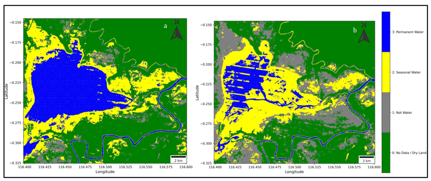
ENSO is an important driver of hydroclimate variability in Indonesia and is strongly suspected to influence the dynamics of floodplain lakes. However, no study to date has combined the ENSO index (SOI) and satellite permanent water area time series for Lake Semayang. This study examines these linkages using 30 m resolution satellite image time series for 2000-2020. Permanent water area was obtained from JRC Global Surface Water, while SOI from NOAA. Monthly series were aligned and aggregated annually; the SOI-PWA relationship was analyzed by Pearson correlation and monthly lead-lag exploration (cross-correlation). The trend of the original annual series was tested nonparametrically with Mann-Kendall and the slope was estimated using Theil-Sen. Results showed a significant positive relationship between annual SOI and permanent water area of Semayang Lake (r = 0.591; p = 0.0048; r² ? 0.35). Monthly explorations displayed peaks at small positive breaks, but at the annual scale the strongest relationships were contemporaneous (same year). The original annual series show no significant monotonic trend over 2000-2020 according to the Mann-Kendall test, and the Theil-Sen estimates are small with confidence intervals that include zero. This finding confirms that La Niña trending conditions are associated with permanent water area expansion, while El Niño trending conditions are associated with shrinkage, making interannual variability the main driver of lake area change. The practical implications are that SOI information can be utilized for seasonal perspectives in navigation, fisheries and flood preparedness, and integrated into regional-level water resources management and climate adaptation planning in lowland wetlands in the region.
References
Aldrian, E., & Susanto, R. D. (2003). Identification of three dominant rainfall regions within Indonesia and their relationship to sea surface temperature. International Journal of Climatology, 23(12), 1435-1452. https://doi.org/10.1002/joc.950
Ariska, M., Irfan, M., & Iskandar, I. (2024). Spatio-temporal variations of Indonesian rainfall and their links to Indo-Pacific modes. Atmosphere, 15(9), 1036. https://doi.org/10.3390/atmos15091036
Darmawan, S., Setiawan, B., & Nugroho, S. P. (2018). Land use change and its impact on the hydrological conditions of the Mahakam watershed. Environmental Management and Sustainability Journal, 7(2), 88-102.
European Commission Joint Research Centre. (2023). Global Surface Water Mapping Layers, v1.4 (JRC/GSW1_4). Accessed March 5, 2025, from https://developers.google.com/earth-engine/datasets/catalog/JRC_GSW1_4_GlobalSurfaceWater
GeoPandas contributors. (2020). geopandas/geopandas: v0.8.1 (Version v0.8.1). Zenodo.
Gillies, S., et al. (2013–2025). Rasterio: access to geospatial raster data (Documentation). Accessed March 5, 2025, from https://rasterio.readthedocs.io/
Gorelick, N., Hancher, M., Dixon, M., Ilyushchenko, S., Thau, D., & Moore, R. (2017). Google Earth Engine: Planetary-scale geospatial analysis for everyone. Remote Sensing of Environment, 202, 18-27. https://doi.org/10.1016/j.rse.2017.06.031
Harris, C. R., Millman, K. J., van der Walt, S. J., et al. (2020). Array programming with NumPy. Nature, 585(7825), 357-362.
Hoyer, S., & Hamman, J. J. (2017). xarray: N-D labeled arrays and datasets in Python. Journal of Open Research Software, 5(1), 10.
Hunter, J. D. (2007). Matplotlib: A 2D graphics environment. Computing in Science & Engineering, 9(3), 90-95.
Kurniadi, A., Weller, E., Min, S.-K., & Seong, M.-G. (2021). Independent ENSO and IOD impacts on rainfall extremes over Indonesia. International Journal of Climatology, 41(6), 3640-3656. https://doi.org/10.1002/joc.7040
Lin, S., Chen, C., Wang, B., Cai, W., & Lee, J.-Y. (2024). Enhanced impacts of ENSO on the Southeast Asian summer monsoon under global warming. Geophysical Research Letters, 51, e2023GL106437. https://doi.org/10.1029/2023GL106437
Marzuki, M., Ramadhan, R., Yusnaini, H., Juneng, L., Tangang, F., Vannisa, M., Afdal., Abdillah, M. R. & Hidayat, R. (2025). Future projections of extreme precipitation over Indonesia’s new capital under climate change scenario using CORDEX-SEA regional climate models. Atmospheric Research, in press. https://doi.org/10.1016/j.atmosres.2025.108389
McBride, J. L., & Nicholls, N. (1983). Seasonal relationships between Australian rainfall and the Southern Oscillation. Monthly Weather Review, 111, 1998-2004.
McKinney, W. (2010). Data structures for statistical computing in Python. Proceedings of the 9th Python in Science Conference, 56-61.
NOAA Physical Sciences Laboratory. (2025). Southern Oscillation Index (SOI) monthly time series. Accessed March 5, 2025, from https://psl.noaa.gov/data/timeseries/month/SOI/
Nurjaya, I. W., & Setiawan, R. Y. (2021). Impact of ENSO on the variability of permanent water area in Indonesia. Indonesian Fisheries Research Journal, 27(2), 103-118.
Pekel, J-F., Cottam, A., Gorelick, N., & Belward, A. S. (2016). High-resolution mapping of global surface water and its long-term changes. Nature, 540, 418-422.
Purwaningsih, A., Lubis, S. W., Hermawan, E., Fatchurohman, D., & Hadi, T. W. (2022). Moisture origin and transport for extreme precipitation over Indonesia’s new capital city, Nusantara in August 2021. Atmosphere, 13(9), 1391. https://doi.org/10.3390/atmos13091391
Python-dateutil contributors. (2024). python-dateutil (v2.9.0.post0) documentation. Accessed March 5, 2025, from https://dateutil.readthedocs.io/
Rioxarray developers. (2020–2025). rioxarray documentation. Accessed March 5, 2025, from https://corteva.github.io/rioxarray/
Seabold, S., & Perktold, J. (2010). Statsmodels: Econometric and statistical modeling with Python. Proceedings of the 9th Python in Science Conference, 57-61.
Trenberth, K. E. (1997). The definition of El Niño. Bulletin of the American Meteorological Society, 78(12), 2771-2777.
Virtanen, P., Gommers, R., Oliphant, T. E., et al. (2020). SciPy 1.0: Fundamental algorithms for scientific computing in Python. Nature Methods, 17(3), 261-272.
Wetzel, R. G. (2001). Limnology: Lake and River Ecosystems. Academic Press.
Wu, Q. (2020). geemap: A Python package for interactive mapping with Google Earth Engine. Journal of Open Source Software, 5(51), 2305. https://doi.org/10.21105/joss.02305
Xu, L., Zhou, W., Chen, W., & Chan, J. C. L. (2022). Variations of summer extreme and total precipitation over Southeast Asia based on self-organizing maps. Journal of Climate, 35(19), 6291-6310. https://doi.org/10.1175/JCLI-D-21-1020.1
Downloads
Published
Issue
Section
License
Copyright (c) 2025 Muhammad Riza, Najwan Al-Ghifari, Zetsaona Sihotang, Nanda Khoirunisa, Mislan, Idris Mandang

This work is licensed under a Creative Commons Attribution 4.0 International License.