Identification of Rainfall and Inundation pattern using remotely sensed data in Lake Sentarum Floodplain Area
DOI:
https://doi.org/10.51264/inajl.v2i2.16Keywords:
inundation pattern, Landsat, Lake Sentarum, rainfall pattern, remote sensingAbstract
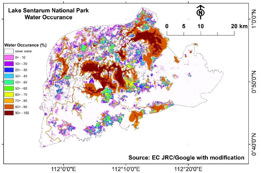
Wetlands are vulnerable natural habitats that should be preserved to protect habitat for fish and wildlife, flood mitigation, improve water quality, recharge area, and maintain surface water flow during dry periods. Water bodies and swamp areas are two primary components of the wetland. Considering its essential roles for the ecosystem, Lake Sentarum was set as a national park area (Lake Sentarum National Park – TNDS), Indonesia's 15 national priority lakes, and; designated as a Ramsar site (The Convention on Wetlands) in Indonesia. Despite the significant roles for the ecosystem, providing the limnological characteristic of Lake Sentarum remains a challenge due to its remote location. This study aims to identify the rainfall and inundation characteristics in the Lake Sentarum area and develop the rainfall-inundation relationship in the TNDS area. First, we carried out rainfall analysis using the Climate Forecast System Reanalysis (CFSR) data. Second, we utilized a remote-sensing-based global surface water map from the Joint Research Centre (JRC) to describe the historical inundation pattern. Third, we applied the Normalized Different Water Index (NDWI) combined with Modification Normalized Different Water Index (MNDWI) to the selected Landsat dataset to extract the inundation area. Finally, we developed a rainfall-inundation relationship in the TNDS area. The result indicated that the yearly rainfall in the TNDS area has an increasing trend, with the highest peak in December and the second peak in April. Historical Landsat data shows that the TNDS has a complex pattern of inundation. The maximum water extent was 649 km2, with a 95 km2 as permanent (90>- 100 % water occurrence). These areas were constantly flooded, even in the dry season. The most significant non-permanent water was 161 km2 (80>- 90 % water occurrence). This permanent and larger temporary water area provides fish and other aquatic biotas habitats. It temporarily stores the water flowing slowly into the River Kapuas through the Tawang River. We captured the spatial inundation pattern and its relationship with the temporal regional rainfall. The developed relationship showed a lag of -60 days of accumulated rainfall correlated with the inundation area (R2 of 0.48, n=11). These findings will thus provide valuable data for lake managers and policy-makers to protect the biota and habitat in Lake Sentarum National Park area.
References
Anshari, G., Kershaw, A.P., van der Kaars, S., & Jacobsen, G. (2004). Environmental change and peatland forest dynamics in the Lake Sentarum area, West Kalimantan, Indonesia. Journal of Quaternary Science 19(7): 637-656
Anshari, G.Z. (2002). Taman Nasional Danau Sentarum : Lahan Basah Terunik di Dunia. Yayasan Konservasi Borneo dan Riak Bumi. Romeo Grafika Pontianak. 48 p. (in Bahasa Indonesia)
Arnesen, A.S., Silva, T.S.F., Hess, L., Novo, E., Rudorff, C., Chapman, B., McDonald, K. (2013). Monitoring Food Extent in the Lower Amazon River Floodplain Using ALOS/PALSAR ScanSAR Images. Remote Sensing of Environment 120. 51- 61
CFSR- Climate Forecast System Reanalysis. Available online: https://climatedataguide.ucar.edu/climate-data/climate-forecast-system-reanalysis-cfsr (last accessed on May 31, 2021)
Chopra R., Verma, V.K., Sharma, P.K. (2001). Mapping, monitoring and conservation of Harike wetland ecosystem, Punjab, India, through remote sensing. International Journal of Remote Sensing 22: 89–98
Dianto, A., Afandi, A.Y., Zahid, A., Rahmadya, A., Sunaryani, A., Rohaningsih, D., Verawati, D., Daruati, D., Ali, F., Rustini, H.A., Wibowo, H., Ridwansyah, I., Subehi, L., Anwar, M., Novianti, R., Oktaviani, T.S., Sudriani, Y. (2020a). Identifikasi Danau Indonesia Seri Maluku dan Papua. ISBN 978-979-8163-33-3, Pusat Penelitian Limnologi – LIPI. (Indonesian version)
Dianto, A., Afandi, A.Y., Zahid, A., Rahmadya, A., Sunaryani, A., Rohaningsih, D., Verawati, D., Daruati, D., Setiawan, F., Ali, F., Rustini, H.A., Wibowo, H., Ridwansyah, I., Subehi, L., Yulianti, M., Anwar, M., Novianti, R., Oktaviani, T.S., Sudriani, Y. (2020b). Identifikasi Danau Indonesia Seri Sumatera. ISBN 978-979-8163-30-2, Pusat Penelitian Limnologi – LIPI. (Indonesian version)
Dianto, A., Afandi, A.Y., Zahid, A., Rahmadya, A., Sunaryani, A., Rohaningsih, D., Verawati, D., Daruati, D., Ali, F., Rustini, H.A., Wibowo, H., Ridwansyah, I., Subehi, L., Yulianti, M., Anwar, M., Novianti, R., Oktaviani, T.S., Sudriani, Y. (2020c). Identifikasi Danau Indonesia Seri Jawa, Bali, dan Nusa Tenggara. ISBN 978-979-8163-31-9, Pusat Penelitian Limnologi – LIPI. (Indonesian version)
Dianto, A., Afandi, A.Y., Zahid, A., Rahmadya, A., Sunaryani, A., Rohaningsih, D., Verawati, D., Daruati, D., Ali, F., Rustini, H.A., Wibowo, H., Ridwansyah, I., Subehi, L., Anwar, M., Novianti, R., Oktaviani, T.S., Sudriani, Y. (2020d). Identifikasi Danau Indonesia Seri Sulawesi. ISBN 978-979-8163-32-6, Pusat Penelitian Limnologi – LIPI. (Indonesian version)
Dianto, A., Afandi, A.Y., Zahid, A., Rahmadya, A., Sunaryani, A., Rohaningsih, D., Verawati, D., Daruati, D., Ali, F., Rustini, H.A., Wibowo, H., Ridwansyah, I., Subehi, L., Anwar, M., Novianti, R., Oktaviani, T.S., Sudriani, Y. (2020e). Identifikasi Danau Indonesia Seri Kalimantan. ISBN : 978-979-8163-34-0, Pusat Penelitian Limnologi – LIPI. (Indonesian version)
Frazier, P. S, and Page, K.J. (2010). Water Body Detection and Delineation with Landsat TM Data. Photogrammetric Engineering & Remote Sensing, 66 (12):1461-1467
Fuka, D.R., Walter, M.T., MacAlister, C., Degaetano, A.T., Steenhuis, T.S., Easton, Z.M. (2013). Using the Climate Forecast System Reanalysis as Weather Input data for watershed models. Hydrology Processes. 11 pages
Giesen, W. (1987). Danau Sentarum Wildlife Reserve: Inventory, ecology and management guidelines. World Wildlife Fund Report
Giesen, W. (1995). The Flood Forest and Black Water Lake of Sentarum Wildlife Reserve, West Kalimantan. AWB-PHPA. Bogor. 73 pp
Gunawan, et al. (2013). Tinjauan Limnologis, Permasalahan dan Solusi Perairan Darat Indonesia. Laporan Tahunan. Puslit Limnologi: 374 hal. (in Bahasa Indonesia)
Hidayat, H., Teuling, A.J., Vermeulen, B., Taufik, M., Kastner, K., Geertsema, T.J., Bol, D.C.C., Hoekman, D.H., Haryani, G.S., Van Lanen, H.A.J., Delinom, R.M., Dijksma, R., Anshari, G.Z., Ningsih, N.S., Uijlenhoet, R., Hoitink, A.J.F. (2017). Hydrology of inland tropical lowlands: the Kapuas and Mahakam wetlands. Hydrol. Earth Syst. Sci., 21, 2579-2594. DOI: 10.5194/hess-21-2579-2017
JRC-Joint Research Centre. Available online: https://global-surface-water.appspot.com/download (last accessed on May 31, 2021)
McFeeters, S.K. (1996). The Use of the Normalized Difference Water Index (NDWI) in the Delineation of Open Water Features. International Journal of Remote Sensing, 17(7): 1425-1432
MoE-Ministry of Environment of the Republic of Indonesia. (2011). Profil 15 Danau Prioritas Nasional; Kementerian Lingkungan Hidup Republik Indonesia: Jakarta, Indonesia; pp. 1–148
Munyati, C. (2000). Wetland change detection on the Kafue Flats, Zambia, by classification of a multitemporal remote sensing image dataset. International Journal of Remote Sensing 21:1787–1806
Nanson, G. C. & Croke, J. C. (1992). A genetic classification of floodplains. Geomorphology, 4 (6), 459-486
Pekel, J.F., Cottam, A., Gorelick, N., Belward, A.S. (2016). High-resolution mapping of global surface water and its long-term changes. Nature, vol 450: 418-422
Reis, S and Yilmaz, H.M. (2008), Temporal monitoring of water level changes in Seyfe Lake using remote sensing, Hydrological Processes, Published online in Wiley InterScience
Ridwansyah, I and Alkadri, M.H. (2014). Karakteristik Danau-Danau di Meliau sebagai Dasar Penerapan Jasa Lingkungan, Prosiding Seminar Nasional Limnologi VII - 2014. Puslit Limnologi-LIPI: 419p. (in Bahasa Indonesia)
Saha, S., Moorthi, S., Pan, H.L., Wu, X., Wang, J., Nadiga, S., Tripp, P., Kistler, R., Woollen, J., Behringer, D., Liu, H., Stokes, D., Grumbine, R., Gayno, G., Wang, J., Hou, Y.T., Chuang, H., Juang, H.M.H., Sela, J., Iredell, M., Treadon, R., Kleist, D., Delst, P.V., Keyser, D., Derber, J., Ek, M., Meng, J., Wei, H., Yang, R., Lord, S., Dool, H.V.D., Kumar, A., Wang, W., Long, C., Chelliah, M., Xue, Y., Huang, B., Schemm, J.K., Ebisuzaki, W., Lin, R., Xie, P., Chen, M., Zhou, S., Higgins, W., Zou, C.Z., Liu, Q., Chen, Y., Han, Y., Cucurull, L., Reynolds, R.W., Rutledge, G., and Goldberg, M. (2010). The NCEP Climate Forecast System Reanalysis. Bulletin American Meteorological Society 91:1015-1057
USGS Earth Explorer. Available online: https://earthexplorer.usgs.gov/
Welcomme, R.L. (1985). River Fisheries. FAO. Technical Paper No. 262, Rome: 320
Xu, H. (2005). Modification of normalized difference water index (NDWI) to enhance open water features in remotely sensed imagery, International Journal of Remote Sensing, 27 (14), Publisher: Taylor & Francis: 3025–3033.